
Preliminary Washington Flood Maps
New and Preliminary Washington Flood Maps provide the public an early look at a home or community’s projected risk to flood hazards. This page is for homeowners who want to understand how their current effective Flood Map may change when the preliminary FEMA maps becomes effective.
Releasing Preliminary Washington Flood Maps
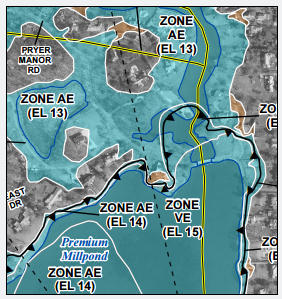
The release of preliminary flood hazard maps, or Flood Insurance Rate Maps (FIRMs), is an important step in the mapping lifecycle for a community. This release provides community officials, the public, and other stakeholders with their first view of the current flood hazards, which include changes that may have occurred in the flood risks throughout the community, or county, since the last flood hazard map was published.
Property Owners Can Take Advantage of “Grandfathering”
If a property is mapped into a high-risk area (shown as a zone labeled with letters starting with “A” or “V”) and the owner has a mortgage through a federally regulated or insured lender, flood insurance will be required when the FIRM becomes effective. Lenders do have the option to make the purchase of flood insurance a condition for their loans at any time, and some lenders may institute such requirements in advance of the maps becoming effective.
Preliminary Flood Map Review:
Current & New FEMA Flood Maps
Current Flood Maps
Dispute your FEMA Flood Zone with a Letter of Map Amendment (LOMA)